-->
Drop Down MenusCSS Drop Down MenuPure CSS Dropdown Menu
Showing posts with label Geology. Show all posts

Friday, May 13, 2016

The oldest crystals formed from an Asteroid

Some pieces of the oldest rocks on Earth have been discovered, and named Zircon crystals. The researchers also found that the old stones are formed in the crater of which came from the asteroid at the time of the initial formation of the planet. The Zircon crystals are older than 4 billion years, while the Earth itself has an age of 4.5 billion years. And this ancient crystal is arguably in the history of planet Earth.

Fifteen years ago, the first crystal had been made the headlines when the research going into the rock formations that revealed the presence of water on the surface of the Earth after the planet formed. Since the study was published, scientists hope the Zircon crystals can give another answers about the history of this planet. 
A zircon crystal from the Sudbury crater pictured through an electron microscope. (Picture from: http://adf.ly/1aBlQO)
Previously, the scientists believed that Zircon crystals formed when tectonic plates collide, in a process similar to the disorder that creates the mountains, volcanic activity and earthquakes. However, most researchers believe, the stone was originated of tectonic plates about 3 billion years ago. Thus, Zircon crystals formed about 1 billion years before the tectonic plates can create the stones.

In a recent study conducted by Trinity College Dublin, Ireland, the investigators pursuing the hypothesis that crystals formed in the crater that was created when an asteroid hit the Earth. To test their idea, then the researchers collected the Zircon crystals from Sudbury crater in Ontario, Canada, which have confirmed the second oldest on Earth nearly two billion years old.

"What we found was quite surprising. Many people think the zircon crystals are very old-fashioned not possibly have been formed in the crater, but now we know they may choose," said Gavin Kenny, a researcher from Trinity College Dublin and co-author of the study, as reported by LiveScience on Friday, May 6, 2016.

The impact of this asteroid is made Earth's crust to melt and form a lava lake. Most of the area around the crater heated and starting to cold, on condition that allows the Zircon undergone a process of crystallization.

"Our new findings would fill more than what we know about the Earth," said Kenny further. By determining the origin of the crystals will help the scientists gather how the planet was form in the beginning and how the life began to emerge on the Earth. *** [EKA | FROM VARIOUS SOURCES | LIVESCIENCE]
Note: This blog  can be accessed via your smart phone

Thursday, April 28, 2016

The rise of the mountain's more horrible than the nuclear threat?

It turns out there is more terrible than the North Korean nuclear threat, which is a force of nature. The international team is now researching Mount Paektu, which is located in the North Korean border with China.

Last eruption of Mt. Paektu happened thousands of years ago and the second largest in recorded in the human history, after the eruption of Mt. Tambora in Indonesia in 1815. In recent years the volcano showed signs of rise. If that happens, the consequences could be catastrophic.
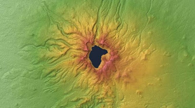
Mount Paektu, on North Korea’s border with China. (Picture from: http://adf.ly/1ZercQ)
"If until the eruption happens, the impact will be felt by Korea and China," said James Hammond, one of the scientists of University of London who involved in the study, as quoted on the New Scientist on Monday, April 18, 2016.

In 946 AD, the eruption of Mt. Paektu is the highest mountain in the Korea, threw about 96 cubic kilometers of material into the sky. The number is 30 times that of a burst of material from Mt. Vesuvius that buried the city of Pompeii in 79 AD. At that time Mt. Vesuvius throws 3.3 cubic kilometers of material.

Although the size and impact of the eruption is enormous, but little information is known about the mountain that is considered 'sacred'. Why is sacred? North Korean leader Kim Jong-il (Kim Jong-un's father) touted was born in the secret camp near Mt. Paektu. That said, his birth was full of the supernatural signs like appearance of bright stars, the season suddenly changed from winter to spring. The founder of North Korea, as well as lifetime president Kim Il-sung also reportedly born in the mountain.

Need cooperation across the country to uncover the mystery of Mt. Paektu. The researchers of western countries was involved in the study, because the North Korean investigation team, led by Ri Kyong-song of the government’s Earthquake Administration in Pyongyang, requires access to extra scientific equipment and know-how.

The China volcanologist who also monitors the mountain that they call as Changbaishan, also require information from the Korean side. Both the China and North Korea are continuing to monitor Mt. Paektu more closely since the mysterious bulge visible in and around the mountain between 2002 and 2005. The GPS study shows there are the ground deformation, increasing of emission gases, and seismic rumble.
The mysterious bulge visible in and around the mountain between 2002 and 2005. (Picture from: http://adf.ly/1ZercQ)
"It is a priority for both countries. Both have volcano monitoring networks, to keep watch over Mt. Paektu," said Hammond.

Hammond and other researchers from Western countries who were invited to North Korea in 2011, to install six seismometers within 60 kilometers from the mountain -- to detect seismic waves from earthquakes elsewhere in the world through the ground beneath Mt. Paektu.

The seismic waves propagate at different speeds through rock solid and liquid, giving information to the scientists on related what was on the bottom of the mountain. The results show that there is a vast magma beneath the volcano. "It's a mushy mixture of rocks and crystals that melt down through the crust in the depth of about 35 kilometers," says Hammond.

Yet there is no liquid magma pools that form near the surface -- which can be considered as the early symptoms of the eruption. And the researchers should continue to answer many questions about Mt. Paektu, such as where is magma pools formed, how much, and what the implications are.
In 946 AD, the eruption of Mount Paektu, Korea’s highest mountain, blasted 96 cubic kilometres of debris into the sky. (Picture from: http://adf.ly/1ZercQ)
"When the amount of magma reached a certain point with the appropriate pressure, then the volcano may erupt," said Hammond. Until now, researchers have not been sure how much magma accumulated up to Mt. Paektu could erupt.

That's why, Hammond says, the collaboration will continue for some time. "We will discuss what we will do during the next 12 months, and long-term for 5 to 10 years into the future," he said further. After many years of working together, both teams should know each other well, talking about the geology through a translator. There is no political content at all, solely to science.

"There is no political element at all. We are working together to understand a huge volcano. The fact we are entering into a dialogue is a good example that science transcend political differences," said Hammond.

Even Ri Kyong-song spent about a month in the UK completed the study results and draft for publication. North Korea intends to open the door for scientists, through an agency called Piintec. *** [EKA | FROM VARIOUS SOURCES | NEWSCIENTIST]
Note: This blog  can be accessed via your smart phone

Tuesday, April 26, 2016

How hot the volcanic lava are?

When the volcanic lava visible to the eye, the object seemed to burn red and tasted very very hot. What is the temperature of volcanic lava are?

As reported by LiveScience on Thursday, April 21, 2016, the lava is molten rock that shoots out of the volcano. These such objects can flow at temperatures of thousands of degrees Fahrenheit.
Basalt lava flow. (Picture from: http://adf.ly/1Zh1LS)
According to the United States Geological Survey (USGS), the volcanic lava at the lowest temperature is equivalent with the temperature of pizza oven, ie 570 Fahrenheit. In the middle range of lava temperatures, the dark red lava often seen slowly crawling across parts of Hawaii , measures around 895 Fahrenheit.

As for the red-hot lava flows, can reach temperatures of up to 1,165 Fahrenheit. The temperature is still lower than the lava flows with the glowing orange, where the temperatures reach 1,600 Fahrenheit at that point.

And when rock is seriously melting, such as the magma within the Hawaiian volcano of Kilauea, the temperatures can reach 2,120 Fahrenheit or 1,160 Celsius equivalent. Wow!! That's very very hot. *** [EKA | FROM VARIOUS SOURCES | LIVESCIENCE]
Note: This blog  can be accessed via your smart phone

Tuesday, April 12, 2016

Scientists found a similar surface to Mars in India?

A place that is similar to the surface of Mars have been found in India. As reported of India West on Tuesday, April 5, 2016, a team of researchers have identified and documented the existence of jarosite, a rare mineral through the study of streptoskopi in the Matanumadh region, Kachch district, Gujarat India. The study is part of a Mars mission initiated by Space Applications Center (SAC) and the Indian Space Research Organisation (ISRO).

"Matanumadh landscape with assemblages unusual mineral, including jarosite in the land of basalt, resembling geological environment that has many jarosite as identified on Mars," said Saibal Gupta, a professor in the department of geology and geophysics at the Indian Institute of Technology (IIT) Kharagpur to Indo-Asian News sevice.
An image of the Gusev crater on Mars where the Spirit rover examined volcanic basalts in 2007. (Picture from: http://adf.ly/1ZDZVb)
The emergence of rare minerals were first reported from various parts of the Mars by Opportunity, the NASA rover in 2004. Since then, the other robot is also detected jarosite in some of the Red Planet's surface. Jarosite is a mineral found in certain environments. It means that the substance was formed in the extreme and unusual conditions. Previously, jarosite is also found in Australia. But the minerals found in India is more similar to jarosite on Mars.
An image of jarosite mineral. (Picture from: http://adf.ly/1ZDZpf)
"The surface of Mars have experienced the similar conditions some time ago. Thus, the discovery of jarosite is supporting the argument that Matanumadh represent the surface of Mars," said Souvik Mitra of IIT-Khargapur.

Mitra added, "Two important conditions for the formation of jarosite is close to the surface of the water acidic and oxidizing conditions. By studying the process of formation of jarosite in Matanumadh, allows us to understand the final stage of water-based activities in some parts of the surface of Mars."

As we knew, NASA found no evidence of water on Mars last year.

"... In addition to sending robots and sophisticated probe to Mars to study it, the investigation can be carried out in Matanumadh and reduce costs to understand what is happening on Mars billions of years ago," said Gupta.

He also added, "It does not replace human exploration on the surface of Mars, but it was committed in a long time. While waiting for that moment, Matanumadh can be a start to imagine what it's there." *** [EKA | FROM VARIOUS SOURCES | INDIA WEST]
Note: This blog can be accessed via your smart phone

Wednesday, September 23, 2015

A giant 'ocean' found towards Earth's Core

A reservoir with three times the water volume of all the oceans have been found far below the Earth's surface. The discovery may help explain where sea earth came. The water is hidden in the blue stone called ringwoodite located 700 kilometers underground in the mantle, the layer of hot rocks in the Earth's surface and the core.
Blue lagoon: this crystal of blue ringwoodite is being crushed in a lab experiment. The orange circles are regions that have had their water squeezed out of them. (Picture from: http://bit.ly/1QFhPNU)
The large size of the reservoir throws new light on the origin of the Earth's water. Some geologists think the water came when a comet crashed into the planet, but this new discovery supports an alternative discourse that the ocean is gradually flow out of the interior of the Earth.
Fragments of the blue-colored mineral called ringwoodite, synthesized in the laboratory. (Picture from: http://huff.to/1iuH0AK)
"This is good evidence about where the Earth's water comes," said Steven Jacobsen of Northwestern University in Evanston, Illnois. Hidden water can also act as a buffer to the ocean surface, and explaining why they remain the same size for millions of years.
The first terrestrial discovery of ringwoodite by University of Alberta scientist Graham Pearson confirms the presence of massive amounts of water 400 to 700 km beneath the Earth's surface. (Picture from: http://bit.ly/N87xu0)
By measuring the velocity of the waves at different depths, the team can identify where the rock type that has passed a wave. Water layers reveal themselves as the wave slows down, which makes the wave passes the wet stone longer than the dry stone.

Jacobsen first examine what would happen on a wave if the water contains ringwoodite present. He fosters ringwoodite in his lab, and unload the sample through great pressure and suitable temperature at 700 kilometers below.
Schematic partial cross section of the Earth showing the location of ringwoodite, which make up approximately 60% by volume of this part of the transition zone. The diamond containing the water-bearing ringwoodite inclusion found by Pearson et al. (Nature, 2014) originated from approximately 500 km beneath the Earth's surface, where a large mass of water may accumulate by the subduction and recycling of oceanic lithosphere, into the transition zone. (Picture from: http://bit.ly/N87xu0)
Sure enough, they found signs of ringwoodite wet in the transition zone 700 kilometers down, which divides the upper and lower mantle region. In those depths, pressures and temperatures appropriate to squeeze water from the ringwoodite. "It is a stone with water along the boundaries between grains, almost like they were sweating," said Jacobsen.

Jacobsen findings support the recent studies of Graham Pearson of the University of Alberta in Edmonton, Canada. Pearson studied diamonds from the transition zone which has been brought to the surface of the volcano, and found that it contains a water bearing ringwoodite, the first strong evidence that there is plenty of water in the transition zone.

"Since our initial report of hydrous ringwoodite, we find another crystal ringwoodite, also contain water, so the evidence is now very strong," said Pearson. *** [EKA | FROM VARIOUS SOURCES | NEWSCIENTIST]
Note: This blog can be accessed via your smart phone.

Wednesday, June 24, 2015

Nepal earthquake shifted Mt. Everest by 3 centimeters

7.9-magnitude earthquake that rocked Nepal on Saturday, April 25, 2015 not only destroyed the Kathmandu valley and finish more than 8,000 lives. The devastating earthquake also shifted Mount Everest or Qomolangma - the Chinese language - as far as 3 cm to the southwest.

But not until the Nepal quake impact on the world's highest peak, which rises as high as 8,848 meters. Similarly, according to the Agency for Survey, Mapping and Geological Information China.

Chinese media reports, the Beijing government has long put a satellite monitoring system at the top of Everest, since 2005, to monitor the movement of the mountain. A decade later known Everest moves 40 cm to the northeast at a speed of 4 cm per year, and the higher of 0.3 cm per year.
Mount Everest after the Nepal earthquake. (Picture from: http://bit.ly/1Bv7u3O)
"Mount Everest constantly moving to the northeast. And the earthquake made it bounced slightly in the opposite direction," said Xu Xiwei, deputy head of the Institute of Geology, China Earthquake Administration, Beijing was quoted as saying on the China Daily website. "The scale of these movements are normal and do not affect life there."

However, the earthquake that occurred last April reversing the movement of the mountain - to the point where he was 9 months earlier. When the incident, it triggered landslides in the mountains and surrounding areas, in the border region Nepal and China, claimed the lives of many climbers.

Death in large numbers to force a number of tour providers ascent to the highest mountain in the Himalayas cancel the trip for the rest of the season. Recent data from China shows, the second major earthquake that occurred on April 12, with the power of 7.5 SR did not disturb Everest.

The findings of a team of Chinese experts argue that analysis of a number of experts predict earthquakes, Everest may be shifted up to a few meters in the quake Nepal. But predictions of seismologists confirmed that the height did not change the truth.

Located on the border of China and Nepal, the mountain is also known as Sagarmatha by residents of Kathmandu Valley were in meetings Eurasian and Indian tectonic plates.

"By measuring movements, scientists can learn the principles of how the Earth's energies and carve-scale release of energy released," said Xu.

"These measures help us find the source of tectonic movements and observe when abnormal movements occur." *** [EKA | FROM VARIOUS SOURCES | CHINA DAILY]
Note: This blog can be accessed via your smart phone.